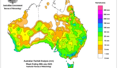
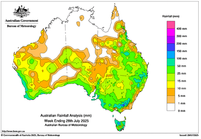
A cold front and the associated low pressure trough brought rainfall to parts of southern Australia at the beginning of the week, with the highest daily totals in northern Tasmania.
Later in the week, a strong cold front associated with a deep low pressure system brought widespread rainfall to most of southern, central and eastern Australia.
 At the end of the week, another cold front led to thunderstorms and showers in south-western Western Australia.
Weekly totals between 10 and 50 mm were recorded in most of New South Wales and southern and eastern Queensland, and large parts of southern Western Australia, southern and central South Australia, southern Northern Territory, Victoria and Tasmania.
Weekly totals between 50 and 100 mm were recorded across Tasmania, coastal areas of south-western Western Australia and south-eastern South Australia, parts of north-eastern and south-eastern New South Wales and eastern Victoria, and isolated areas of central and south-eastern Queensland.
Elevated areas in north-eastern Victoria, northern Tasmania and the Mount Lofty ranges in South Australia, and small areas of the Western Australian west coast, had weekly totals exceeding 100 mm.
The highest weekly total (at a Bureau gauge) was 162.0 mm at Piccadilly (Woodhouse) in South Australia.
The highest daily total at the Bureau gauge was 87.2 mm at Longley (River Bend Road) in Tasmania in the 24 hours to 9 am on 27 July.