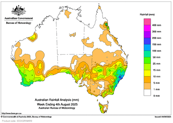
A complex low-pressure system off the north-east coast of New South Wales triggered widespread moderate to heavy rainfall, storms, and flooding across most of state’s east and south-east Queensland.
 Weekly rainfall totals of 50 to 300 mm were recorded across most of eastern New South Wales and many sites had their highest July daily rainfall totals on record in the 24 hours to 9am on 3 August.
Minor to Major flooding occurred in some catchments for northern New South Wales including the Peel River at Tamworth and Namoi River at Gunnedah.
Cold fronts and associated troughs led to scattered rainfall and storms, some severe, across southern Western Australia, South Australia and Tasmania and snow falls in parts of inland New South Wales and south-east Queensland.
Weekly rainfall totals of 25 to 150 mm were recorded across south-west Western Australia, parts of the south-western South Australia, northern inland regions of New South Wales and western Tasmania.
Coastal troughing led to unseasonable light to moderate rainfall across parts of Queensland’s north-east coast.
Weekly rainfall totals of 15 to 100 mm were recorded across the North Tropical Coast and Tablelands districts.
The highest weekly total (at a Bureau gauge) was 322.8 mm at Careys Peak (Barrington Tops) in New South Wales, which included the highest daily total of 150.6 mm in the 24 hours to 9 am on 3 August.