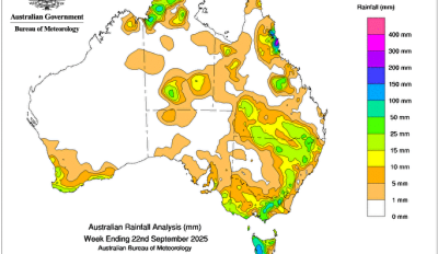
MOIST onshore easterly flow interacted with a surface trough and triggered persistent showers with isolated heavy to intense rainfall across the North Tropical Coast of Queensland for several days.
 Weekly rainfall totals of 15 to 100 mm were recorded in north-eastern Queensland with falls greater than 100 mm in the North Tropical Coast and Tablelands, and Herbert and Lower Burdekin districts.
Low pressure troughs brought rainfall to parts of the Northern Territory, Queensland and New South Wales.
Weekly rainfall totals of 10 to 50 mm were recorded in areas of Northern Territory’s south and Top End, western, southern and central areas of Queensland and northern and south-eastern New South Wales, with isolated falls of 50 to 100 mm in some areas.
Several cold fronts and associated low pressure systems crossed southern Australia during the week and brought widespread rainfall and isolated thunderstorms.
Weekly rainfall totals of 10 to 25 mm were recorded in parts of south-western and southern Western Australia, south-eastern South Australia, large parts of Victoria, areas of southern and eastern New South Wales and most of Tasmania. In Tasmania, falls of 50 to 150 mm were recorded in western and central parts of the state.
The highest weekly total (at a Bureau gauge) was 556.0 mm at Topaz Alert in Queensland, which also included the highest daily total of 379.0 mm, in the 24 hours to 9 am on 17 September.