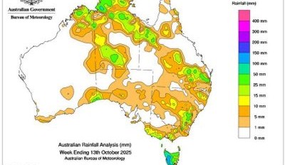
COLD fronts and associated low pressure troughs led to widespread showers and storms, some severe, across Tasmania and parts of the southern mainland.
Weekly rainfall totals of 10 to 100 mm, with locally higher totals up to 200 mm, were recorded across Tasmania, south-western regions of Victoria, including alpine and Gippsland regions, south-eastern and south-western South Australia, southern alpine areas of New South Wales and an isolated area in the Eucla region of Western Australia.
 Isolated thunderstorms and showers impacted parts of northern Australia, delivering light to moderate rainfall to parts of the Kimberley, Cape York Peninsula, and the Top End.
Weekly rainfall totals of 10 to 50 mm, with locally higher totals up to 100 mm, were recorded across parts of the Kimberley, Cape York Peninsula and the Top End.
A cloud band associated with low pressure troughs across inland South Australia, southern Queensland, and northern New South Wales brought showers and isolated thunderstorms, some severe, to parts of central and eastern Australia.
Weekly rainfall totals of 10 to 50 mm were recorded across isolated parts of the southern regions of the Northern Territory, inland Southern Australia, inland and south-eastern Queensland and north-eastern New South Wales.
The highest weekly total (at a Bureau gauge) was 181.8 mm at Mount Read in Tasmania.
The highest daily total (at a Bureau gauge) was 95.2 mm at Old Delamere in the Northern Territory in the 24 hours to 9 am on 12 October.