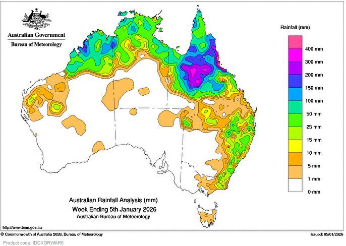
Heavy rainfall and thunderstorms affected northern Queensland, driven by deep tropical moisture interacting with a monsoon low and an embedded trough over western Queensland, along with enhanced onshore winds along the state’s north-eastern coast. This triggered flooding across northern Queensland.
Weekly rainfall totals of 50 to 400 mm were recorded in large parts of northern Queensland, especially in central and north-east regions. More than 500 mm fell along the north-eastern Queensland coast.
Severe Tropical Cyclone Hayley peaked at Category 4 north-west of Broome and made landfall as a Category 3 system on the Kimberley coast on 30 December 2025. It had weakened to a tropical low by 31 December and then tracked east across north-western Australia before dissipating.
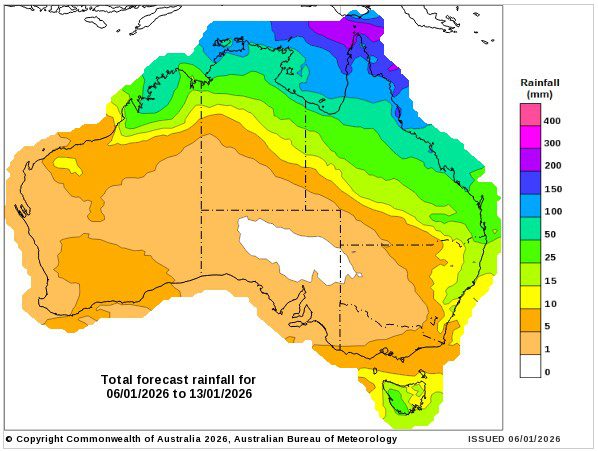
Weekly rainfall totals of 15 to 200 mm, with isolated higher totals, were recorded in northern parts of Western Australia and the Northern Territory.
A trough over western New South Wales drew moisture from the north, bringing thunderstorms, some severe, along with showers and localised heavy rainfall to large areas of eastern New South Wales, parts of south-eastern Queensland, and eastern and central Victoria over the weekend.
Weekly rainfall totals of 10 to 50 mm, with isolated higher totals, were recorded over eastern New South Wales, southern and south-eastern Queensland, and far eastern Victoria.
The highest weekly total (at a bureau gauge) was 1086.4 mm at Cowley Beach (Defence) in Queensland.
The highest daily total (at a bureau gauge) was 414.0 mm at Innisfail Wharf Alert in Queensland in the 24 hours to 9am on 31 December 2025.