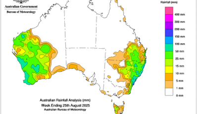
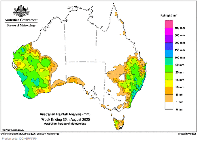
An upper disturbance and surface troughs triggered widespread moderate to locally high rainfall accumulations and thunderstorms across much of eastern New South Wales and south-eastern Queensland.
Rainfall across north-eastern New South Wales has led to major flood level peaks at the Namoi River and moderate flood levels at Peel River this week.
 Weekly rainfall totals of 15 to 100 mm, with locally higher totals to 300 mm, were recorded across much of eastern New South Wales, south-eastern Queensland and isolated parts of eastern Victoria.
Cold fronts and low pressure troughs led to scattered rainfall and storms, some severe, across western parts of Western Australia, southern regions of South Australia and western Tasmania.
Weekly rainfall totals of 10 to 100 mm were recorded across south-western parts of Western Australia and northern and western Tasmania.
A trough brought rainfall to the Pilbara and interior districts of Western Australia.
Weekly rainfall totals of 25 to 50 mm, with locally higher totals to 100 mm, were recorded across parts of the Pilbara, Gascoyne and Southern Interior of Western Australia.
The highest weekly total (at a Bureau gauge) was 295.4 mm at Jervis Bay (Point Perpendicular AWS) in New South Wales.
The highest daily total (at a Bureau gauge) was 148.4 mm at Port Macquarie Airport AWS in the 24 hours to 9 am on 21 August.